mtb loop
The MTB Loop is the main track that runs along the north side of the Ashburton River. Since 2009, the majority of the trail has been developed and maintained by members of Mountain Bike Ashburton, with support from Environment Canterbury and the Ashburton District Council.
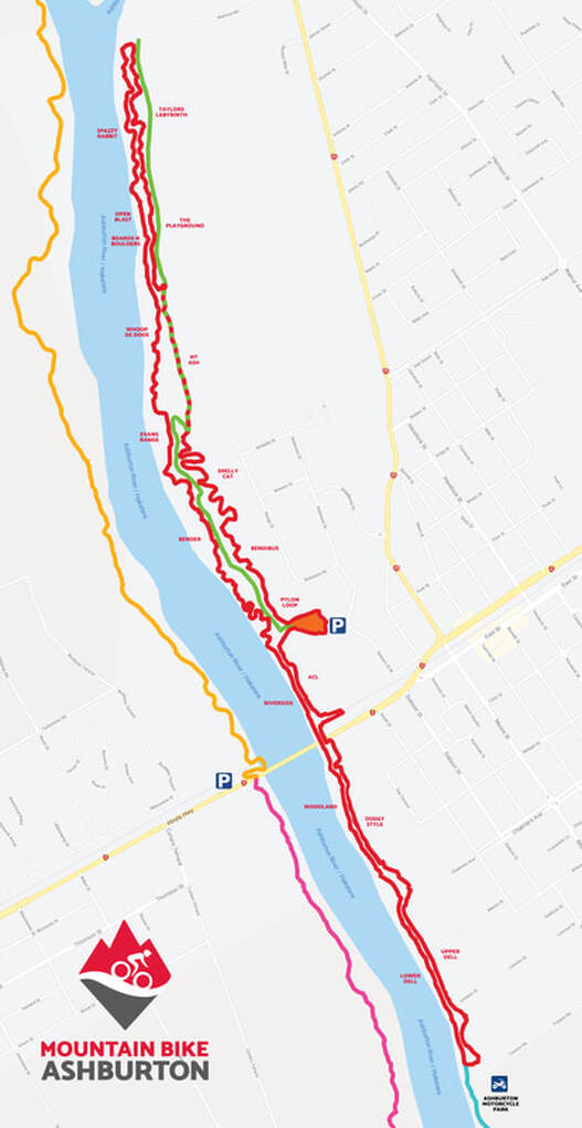
The MTB Loop is 11.5km long, rated Grade 3 under the New Zealand grading system and is suitable for most riders with some mountain biking experience. Our trails are also e-bike friendly.
There are 19 different named sections of track (detailed below), with the main entrance being at the Skills Park on Dobson Street West, Ashburton where car parking is available. The following descriptions are given in the order that you would ride the track from this entrance.
|
ACL
ACL is named after Ashburton Contracting Limited whose landscaping supplies yard backs onto the trail. These guys have been extremely supportive of our track development, frequently giving us a great deal on machinery and materials. This section flows nicely along the back of ACLs yard before climbing 'Mt Maurice' then ending under the rail bridge - remember to duck! |
Doggy Style
Not what you think! This section goes alongside one of the Council's Dog Exercise Parks, so is aptly named. A varied piece of track with some nice woodland sections, a bit of a hill climb and stopbank traverses. You'll be panting like the dogs at the end of this one! |
|
Upper Dell
The Upper Dell track was mostly part of the original Ashburton/Hakatere River Trail developed by the council but has since had additions and modifications. It is separated from Lower Dell by native plantings put in by our club in 2010 and is generally undulating with good tree cover throughout. Upper Dell turns just before Trevor's Road to head back upstream. If you are looking for a longer ride you can turn left where a trail follows the river approximately 17km to the river mouth at the coast. The settlement here is called Hakatere. Beware, coming back is more uphill than you think! |
Lower Dell
Named after our first president Dell Phillips who, after a few incidents when the track was two way, became somewhat obsessed with making the trail a one way loop. The Lower Dell track was the final piece in the puzzle, back in 2016, giving us the 12km loop we enjoy today. Lower Dell became the subject of flooding several times in 2017 being so close to the river and has since been built up to get above the water! |
|
Woodland
As the name suggests this section has good tree cover starting with mainly native Pittosporums before leading through mixed Poplar, Willow and Sycamore. Generally tight and twisting this track keep you on your toes all the way to the main road bridge. |
Riverside
A fast flowing section upstream of the main road, this area is prone to flooding and was built up, resurfaced and then shifted in 2021 to get further away from the river after a massive flood. |
|
Bender
This area was done in two sections, making it the longest section of the MTB Loop. After the first section was put in between 2012 - 2013 we had huge issues with drainage. This resulted in some fairly major changes with boardwalks, drainpipes and building up of the track making a big difference to the rideability of this section. Big ups to James Reid for driving this project. The second section starts over a cool 40m raised boardwalk spanning a natural wetland featuring native grasses, ferns and cabbage trees, and flows through large poplar and willow stands. This section was put in by Geoff Evans and Dell Phillips, who after a fairly big night, spent eight hours on a chainsaw cutting through the fallen trees and two metre high blackberry to define the track and come up with the name which describes both this section of the track and their big night out... |
Evans Range
This sweet little man-made hill was formed and named after Geoff Evans who has been heavily involved with our club since day one, donating both time and machinery to help achieve the quality trails we enjoy today. Evans Range goes through an area affectionately known as the graveyard, which is in reference to the stockpile of old concrete placed there by a previous generation. You'll find an optional drop near the end. |
|
Whoop De Doos
Once upon a time just a overgrown animal track, Peter Ayers and Paul Kuriger pruned and opened up Whoop De Doos to bikers in 2009. This section is generally fast and flowing with a few tighter twists and turns to keep everyone honest. Watch out for the 'old mans beard' hanging from the trees ready to snag an unwary handlebar. This noxious plant was brought to our country as an ornamental climber for home gardens - what were the English thinking?! |
Open Blast
As the name suggests, this section flows through a fairly open area that once had sheep grazing on it. Always a favourite for roadies where they catch up to the more technical riders! If you are looking for something slightly more technical, take a right at the start of Open Blast onto Boards n Boulders. |
|
Boards n Bolders
Aptly named, Boards n Bolders features some boardwalks and rock gardens which has managed to claim a few victims. Peter Ayers, James Reid and crew dragged trailer loads of rocks down from Mt Hutt to build the short track in 2013. |
Spazzy Rabbit
The long awaited connection between the Playground and Melrose was completed in 2018 with funds raise from our annual 6 Hour Race. Spazzy Rabbit was built by local trail builders D&E Track and Trail, taking the track off the straight, flat stopbank where the roadies always used to thrive! This section will keep you on your toes with hardly any straight sections for catching your breath, just berm after berm! |
|
Taylors Labyrinth
A very cool section at the top end of the MTB Loop, named after one Brian Taylor who put a huge effort in making the most of the natural topography in this area. Brian often went down with his ladder to aid in finding the best route through what was then a pretty overgrown jungle of blackberry and fallen trees with help of Paul Kruiger and Peter Ayers. We think it's fair to say he succeeded in his mission. The track was opened in 2011 thanks to some free diggers from Ashburton U-Hire. In 2018 the track was reworked in places while constructing Spazzy Rabbit. It now has bigger berms than ever! |
The Playground
A funky wee section that dips and dives through natural undulations among old willow trees and features a of bridge. This local's favourite section of track was marked out and formed by Justin McMillan and Craig Cullimore in 2009. |
|
Mt Ash
At last our one and only real hill on the MTB Loop. Mt Ash (or dump hill) features stunning views of the surrounding countryside including our local refuse station and industrial area..... Contrary to popular belief Mt Ash wasn't formed by geological activity but has been created by the covering and sealing of Ashburton's former landfill - truly a gem. The downhill track has been shifted and rebuild twice due to closures for Council work. At the end of Mt Ash you have the choice of two options, one being a steep rock slab and the other a longer, safer option. Please ride to your ability. |
Smelly Cat
This section was marked and formed in 2013 by Dell Phillips and Geoff Evans with funding from our successful 6 hour event held in May of that year. The aim was to put as long a section as possible through a big stand of Poplars to add some more distance to our existing loop. This section runs parallel to our sometimes odoriferous resource park and is frequented by feral cats, hence the naming. In 2018 with profits from our 6 hour race D&E Track and Trail came along and installed large berms along this whole section making it the fast and brake-less track it is now! |
|
The Highway
This is an old haul road previously used by Ashburton Contracting Limited to extract gravel from the riverbed for their screening plant. It links Smelly Cat to the Pylon Loop and as the name suggests is another two lane race track, but very handy for accessing other parts of the loop for working bees and maintenance. |
Bendibus
Built by club members by machine and hand in 2020/2021 this section was largely funded by Trail Fund NZ. The goal was to make the track reasonably straight to keep the speed up then create a few optional harder lines near the end. |
|
|
Strava |
Videos |
|
Members of the committee have created Strava sections for all segments on the track, with the name of the segment matching the name on the trail signs. The segments start at the trail sign (with the name of the track) and end at the next one. All new tracks will be added to Stava by the committee.
|
You can find videos of most of the MTB Loop on the BikeHQ YouTube Channel. |


